Loch Eport, North Uist - 13/14 July 2006 (day 54/55)
Yacht Gothik
At Anchor
Bagh a' Bhiorain
Loch Eport (Loch Euphoirt)
North Uist
Outer Hebrides
13 July 2006
| << Loch Skipport, South Uist - 12 July | Home | Scalpay, Harris - 15 July >> |
Click here to see a map.
Logged distance: 19M
Chart distance: 19M
Time under way: 4h30m
Thursday 13 July 2006
Today started grey and overcast. Very grey and overcast in fact - no pictures today. Keith and Ben headed off in the dingy for a bathe in the lake, too cold for me - besides, I'd had my bath yesterday - they came back with the water containers filled with what looked like tea. The peaty water may have looked a little disconcerting but the taste was sweet and pure.
Just after lunch we left our magical spot in the Wizard Pool and into a light west-north-westerly. Since our heading was north-north-east it made for a day of very easy sailing. Shame it was so cloudy. Ben got the fishing tackle out but it was not long before an impressive jerk on the line cracked the reel. We heard the crack, Ben wound in what was left of our tackle - no hooks, no lures and no paravane. No luck today then. We have nothing to fish with until we find another tackle shop.
The island of Benbecula slid slowly past to the west of us; low lying and almost unnoticed. North Uist seemed to be just a hilly extension to it. The land around here takes a very similar shape and navigating by sight can cause a few surprises. Like a book, if you take your eye off the page you loose your place - if you take your eye off the chart you lose where you are. Today I took my eye off the chart. We were steering for a headland about two miles distant when Ben piped up with "The GPS says we've arrived". "No Ben, a little bit further." But I looked around just to be sure. There was no sign of a loch entrance.
But just as I began to look away there it was. It was the most extraordinary entrance. The north and south sides of the loch appear to merge into one another. It is not until you are right outside the entrance, and looking directly along the centerline of the long narrow loch, do you actually see it.
We were slightly ahead of the planned arrival time. I was a little anxious the tide would be running too fast through the narrow entrance to make a safe approach. If the worst came to the worst I thought we would at least be able to turn the boat into the tide and travel backwards. This would allow us to maintain manoeuvrability and enter the loch at a safe speed. As it happened it was fine; there was only about two knots of tide - the entrance, although narrow, was relatively clear of dangers and as wide as some other places we'd been.
The anchorage was remote and private. We had our own seals and greylag geese to keep us company, although they were all a little shy of us. If we so much as looked at them for more than a few seconds they would either slip into the water or walk over the other side a ridge and out of sight.
Friday 14 July 2006
Logged distance: 2.98M
Chart distance: 3M
Time under way: 1h
 We
awoke this morning to sunshine and blue skies. It was not nearly warm
enough for shorts and t-shirts but still very pleasant and welcome none
the less.
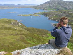
Ben and I paddled the dingy ashore (rowlocks are broke on the dingy) with the intention of climbing the nearest hill to take a look at our surroundings from a viewpoint. In bare feet we padded over soggy peaty soil, heather and bracken - doing our best to avoid trampling the wild flowers and orchids. Very soon we stood at the top. The view was both unexpected and beautiful.
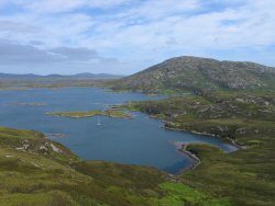
From the water and shoreline it is difficult to form a picture of what is around you. One can tell it is an odd sort of landscape purely from looking at the chart. Hundreds, even thousands, of lakes and islands. Lots of low lying rocky, grassy bumps - until now what it actually looked like when viewed from above was a mystery. I leave you for a moment with a few pictures and to let you marvel at how these waterlogged rocky lumps can be inhabited...
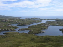 The
view north east. The sea (the straight known as the 'Little Minch') is
in the background. The land in the right of the picture, about 15 miles
distant across the Little Minch, is the Isle of Skye.
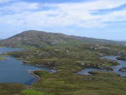 View
to the north-north-west. Loch Eport is on the left, the sea on the far
right. The entrance from the sea into the loch is just this side of the
hill in the background.
 The
view north, looking down upon our anchorage.
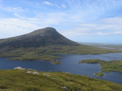 The
view south at the 345m peak of Eaval, North Uist.
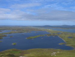 The
view west. The Atlantic Ocean can be seen 8 miles away in the far background.
The stretch of water leading into the picture on the far right is Loch
Eport (as it is written on the chart, or Loch Euphoirt as it is in Gaelic).
The town (of 30 or so houses) is also known as 'Loch Eport' and is strung
along the south side starting from the middle background for about half
its length. The water in the foreground is brackish but not tidal (i.e.
it does not open out into the sea).
The
view west. The Atlantic Ocean can be seen 8 miles away in the far background.
The stretch of water leading into the picture on the far right is Loch
Eport (as it is written on the chart, or Loch Euphoirt as it is in Gaelic).
The town (of 30 or so houses) is also known as 'Loch Eport' and is strung
along the south side starting from the middle background for about half
its length. The water in the foreground is brackish but not tidal (i.e.
it does not open out into the sea).
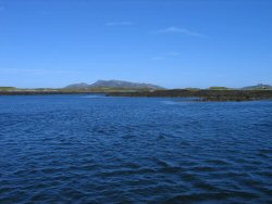 The
view of the same landscape from sea level.
After lunch we started the engine and proceeded 'up stream' toward the head of the loch. I say up-stream because it felt like a large river. It was low tide which made it easy to see the many many obstructions. Seeing these obstructions made it easy to know our exact location on the chart. This in turn made it easy to avoid the many many rocks still beneath the surface.
The wind tonight was expected to reach force 7 from the south east. I wanted to be sure we found a good spot to anchor. Although the anchorage upstream was not as good as the one at the entrance if felt good enough. We laid out a lot of chain and the anchor held fast. The motivation for moving 3 miles further up the loch was to find a pub or a place to eat and hopefully to meet some of the people that actually lived here. If we could find any.
We took the dingy ashore and tied up to a private jetty (home made) to the first house we came across. Keith went and knocked on the door to ask if it was alright to use the jetty. Yes of course it was. In between giving commands to his dog in Gaelic he also suggested that we'd have "...a long long walk to find somewhere to eat or drink" and that we'd "best take the dingy a mile or so further up the loch" where there was a hotel that served very good food. Indeed he frequented it.
He then looked at our dingy - and I guess mostly at the size of our engine - in contrast to ours he had a huge rigid hull inflatable boat with an enormous engine. He suggested that we "may want to wait an hour or so for the tide lessen". He also mentioned there was "a particularly tricky spot where the water runs like a fast river" but his boat usually managed ok. However he thought we "may have a little trouble" and added that we "could always carry the dingy around".
This sounded like an adventure in the making. Ben and I were up for it. Keith looked a little less sure. As usual he trusted my decision but I could see he was thinking "What am I letting myself in for?". We went back to the boat to pick up extra fuel, wet weather gear, life jackets, torch and dingy pump whereupon Keith asked me "What am I letting myself in for?". Honestly I didn't know but we were going to take a look anyway - if it was too bad we could always come back!
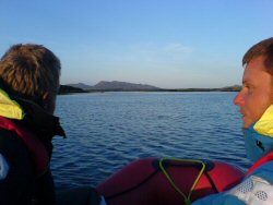 Off
we set, against the tide and upstream. The current was strong but our
little 2hp motor made enough headway; I found I could take advantage of
the eddies and sometimes a slower current closer to the shore. As we got
further up we came to a branch in the 'river'. The right hand branch was
fast flowing - I mean really fast! The left hand branch was far
slower - because of this it felt less like the right way. I thought we'd
best give the left branch a go since we would be impossible to make it
against the flow in the right branch. After another quarter of a mile
the left branch shallowed out to a bottom of soft mud - back to the right
branch.
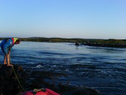
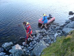
Ben was egging me on to "just power into the stream with full throttle". Since we were currently under full throttle I thought we should go ashore and take a look at what we were doing. I'd never seen anything like it, not at least since my days of canoeing! We looked at the length of the rapid and at whether or not it would be possible to pull the dingy along the shore line. Fortunately we had a very long painter (line attached to the dingy) which made it easier. I would hold onto the dingy while Ben would rock-hop forward along the shore. I would then throw Ben the painter, he would hold onto the dingy while I made my way in front of him. Etc.
It took a while but it was not difficult. About 50m upstream we found a slower moving calm spot, all three of us climbed back into the dingy. From then on the stream was wide with little current. Eventually, at the head of what looked like a lake we reached a ruined boat house, behind which was a young wood and behind that a building that was obviously a hotel. Leaving all our sailing gear in the dingy we marched up to the hotel. We were lucky, there was one table left in the restaurant.
Before our dinner we were able to sit in the garden with a bit of far north sunshine and a glass of wine, and reflect on the fact that we were sitting in probably the western most point on this trip; about 7°15.4' W. The food and service were excellent. But we didn't meet any locals.
Paid the bill and decided to brave the rapids. The tides were all wrong for us, we had the tide against us on the way to the hotel and would now have it against us on the way back to the boat. Actually, I'm not so sure about the tides being wrong. Had the tide been going with us we would have probably shot the rapid, hit a rock and all missed dinner... No the tides were just dandy.
I won't bore you with the return trip other than to say it was actually more fun because we knew what was coming...
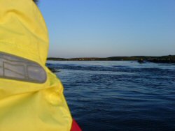 Edging
up as close as we could.
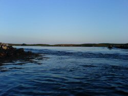 Here
you can get an idea of the difference in height and the volume of water
passing through.
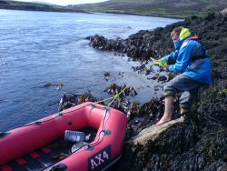 It
took a while to get the dingy round but it wasn't too difficult.
