Talmine, Kyle of Tongue - 29 July 2006 (day 70)
Yacht Gothik
At Anchor
Talmine
Talmine Bay
Kyle of Tongue
Highland
29 July 2006
| << Rispond, Loch Eriboll - 28 July | Home |
Click here to see a map.
Logged distance: 26.5M
Chart distance: 25M
Time under way: 7h
Saturday 29 July 2006
We could no longer hear Stornoway coastguard on the VHF radio. We were out of range. This meant no more weather forecasts from Stornoway coastguard. More significantly this meant no more weather forecasts read out in the sing-song lilting voice of the unknown lady from Stornoway. For just over a month we had heard her voice; "All stations, all stations, all stations. This is Stornoway coastguard, Stornoway coastguard, Stornoway coastguard. For a maritime safety information broadcast please listen..." and we would listen. Keith and I made up our minds to send her a postcard thanking her for the weather.
The weather reports now came from Shetland coastguard. The bad weather expected last night never materialised, instead it was rescheduled for later today. We had planned (if the weather were good) to make passage to Orkney today but now decided to potter around Loch Eriboll; if the weather worsened we would re-anchor for the night in Rispond Bay, if not we would move round the coast to Talmine. The clouds tended to indicate some change was on its way but for now there were only light airs.
 We
raised anchor shortly after ten o' clock and headed under full sail into
Loch Eriboll, just for a sail, just for pleasure. Loch Eriboll is a large
loch, about 10 miles long and 1 to 2 miles wide. It was nice to feel we
were just out for the day, no particular destination, no pre-planned distance
to make good. It seemed a very long time since I had done any of this
type of sailing and indeed it was. This was no doubt thanks to the company
of Phil. If it had been Keith and I aboard by ourselves with the current
forecast we would have probably been content with letting out a little
more chain and settling down with a book in the cabin. Instead we had
a pleasurable cruise to the head of the loch and back. Keith caught some
fine fish along the way.
We
raised anchor shortly after ten o' clock and headed under full sail into
Loch Eriboll, just for a sail, just for pleasure. Loch Eriboll is a large
loch, about 10 miles long and 1 to 2 miles wide. It was nice to feel we
were just out for the day, no particular destination, no pre-planned distance
to make good. It seemed a very long time since I had done any of this
type of sailing and indeed it was. This was no doubt thanks to the company
of Phil. If it had been Keith and I aboard by ourselves with the current
forecast we would have probably been content with letting out a little
more chain and settling down with a book in the cabin. Instead we had
a pleasurable cruise to the head of the loch and back. Keith caught some
fine fish along the way.
 A
few hours after lunch we had returned to seaward end of the loch with
a wind that was now verging on a force 5. We decided to pop out into the
open sea to assess the conditions. It was only a few miles from here to
Talmine and with the wind mainly from the south an anchorage in this very
exposed place would be tenable. It was an easy decision to continue and
one we were happy to make.
A
few hours after lunch we had returned to seaward end of the loch with
a wind that was now verging on a force 5. We decided to pop out into the
open sea to assess the conditions. It was only a few miles from here to
Talmine and with the wind mainly from the south an anchorage in this very
exposed place would be tenable. It was an easy decision to continue and
one we were happy to make.
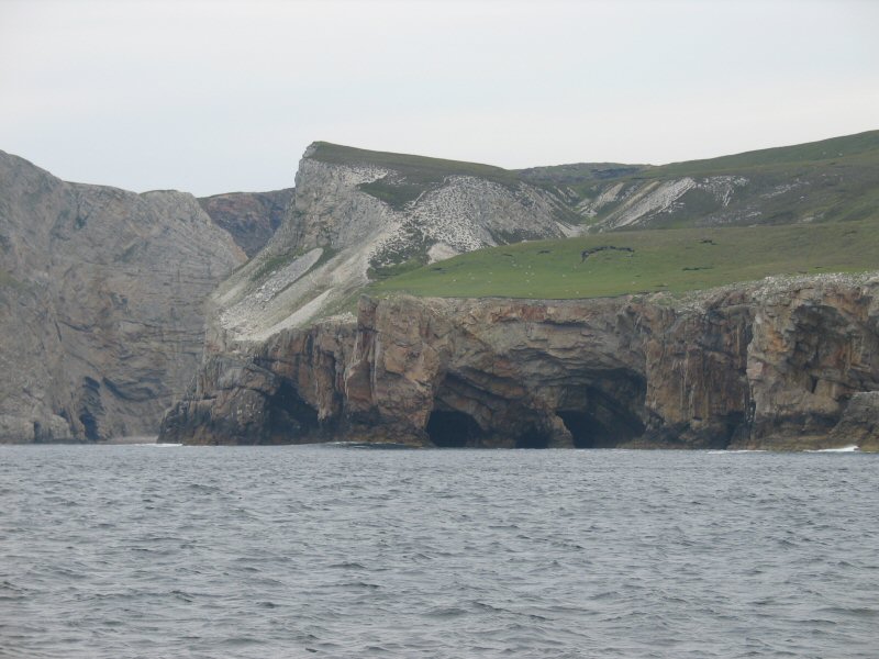
 On
the way out of the loch we steered close to the north eastern shore. The
cliffs were made up of heavily contorted sandstone, full of natural arches
and wave blasted caves. Inaccessible from the land we had a rare vantage
point from the sea and all of us felt privileged at having a boat to view
them from.
On
the way out of the loch we steered close to the north eastern shore. The
cliffs were made up of heavily contorted sandstone, full of natural arches
and wave blasted caves. Inaccessible from the land we had a rare vantage
point from the sea and all of us felt privileged at having a boat to view
them from.

My charts for the north coast (and indeed for the rest of the trip around Britain) were once again using WGS84 survey data (World Geodetic Survey 1984) . For the last month or so we had been navigating using charts based upon OSGB36 (Ordinance Survey of Great Britain 1936). There is little difference in terms of accuracy of the charts, however the latitude and longitude positions of the OSGB36 charts do not correlate precisely with GPS satellite derived positions. Plotting a position from the GPS directly onto an OSGB36 chart can place you some distance from where you actually are. In practice this is only a matter of a few hundred metres but it must be considered in the light of the many navigational hazards. Large scale WGS84 charts are not yet available for north west Scotland but I had got used to (and become fond of) using Admiralty charts printed in the late 1970's and updated by hand. Relics of our maritime history and now consigned to the bottom of the chart table.
By the time we had reached Talmine the wind was force 6. There were many boats in the small bay and we were forced to anchor in a spot that had little shelter from a wind that had steadily backed into the south-east. The first attempt at anchoring seemed to go well - I had asked Phil to lay a lot of chain and the anchor held - however, we soon dragged. The next attempt with 40 metres of chain in 6 metres of water did the trick - I was just sorry for Phil, having to pull (in strong wind) all the chain and the anchor from the first attempt. Well done Phil!
Riding well we settled in for the night and cooked dinner. Phil was keen to go ashore, I must say Talmine looked small and inviting and I was nearly persuaded, but Phil didn't persist in his talk and the dingy remained stowed in its locker. At turn-in time the wind was fierce.